LrsTools for ArcGIS has grown over 20 years as a premier affordable multi-level linear referencing system (MLLRS) solution for Esri's ArcGIS Desktop environment. Many of the business practices introduced by this tool set have been adopted by Esri's own enterprise-LRS solution (i.e. Esri Roads & Highways). LrsTools is proud of its association with Esri R&H. LrsTools for ArcGIS can stand alone OR offer supplemental efficiency solutions that enhance the R&H experience on the ArcGIS Desktop®.
Deploy only to those who are in charge of maintaining your LRS routes. The Advanced toolset provides for the intersection table generator that became the catalyst that allowed Esri to improve the usefulness and acceptance of the Road and Highways methods.
Though route building and intersection tables are the focus of the Advanced toolset -- the toolbox also offers some specialty functions for keeping your temporal data in line - such as the orphaned events finder and the route/event redactor.
Tools/Buttons
Auto Measure Route Part from Control Points
Find LRS Orphans
Route Builder (aka Generate Routes)
Intersection Tables Generator (Make Geocoding Tables)
Intersection Tables Assembler
Polygon to LRS Polyline Transformer
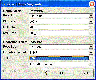
Redact Route Segments
Round Measures on Routes
Route Measure QAQC Utilities
The Advanced toolset includes the most valuable time-savers known to LRS professionals. Routes can be built with all of the typical controls of the Esri toolset -- but enhancements provide for (1) individual route BuiltFrom assignments, (2) one arc gets built into many different named routes, and (3) directional separation of same-directional vs cross-directional route building for arcs of the same name but different orientations.
The Route Builder tool is the optimal choice for preparing your routes (and calibration points automatically) prior to sending routes to Roads & Highways.
__________________________________
The effective LRS practitioner became effective with full control of the human-understood names of routes and references. The Build Intersection Tables wizard allows for the creation of a LRS "library" of all of the routes and crossing features in the geographic domain. And by crossing features -- we mean that any point, line, or polygon boundary becomes a referent along any route that carries inventory characteristics or other types of attributes.
Intersection tables can be generated for large areas (i.e. entire states) at a time, or they can be generated for entire routes, or just for limited are of LRS change (i.e. intersections).
Intersection tables are critical in lesser-evolved methods of bifurcation elimination. They are heavily utilized by event editors in the Lite toolset.
__________________________________
Political and/or administrative boundaries are commonly edited as polygons, but LRS Tools allows them to be represented as lines in an LRS library though the conversion tool provided in the Advanced toolset.
__________________________________
LRS Advanced allows for the redaction of LRS routes and events. Some data users want some particular behaviors of a temporal database without deploying full temporality. While LRS Tools supports temporal routes and events, some users want to hide particular data in production output to users with unique requirements of the master database. Rather than maintain a version for a user with special requirements, redaction serves those special requirements without duplicating any effort. Route redaction will discard portions of routes that data owners wish to eliminate from certain versions of their data. Route redaction is also the easiest way of building simple single-part routes along traversable paths, but then ending up with multi-part routes with measures that closely reflect 2d station readings of the single part route build. Therefore, redaction is an easy way of establishing measures that (in R&H) serve as calibration points.
Event redaction does likewise to events that are temporal, but the data owner doesn't want to mark as retired, or otherwise wants to treat as special.
__________________________________
Assuming your aren't always tied to odometer readings, LRS Advanced does all of the bulk route calibration for you -- so don't get dreary. If you have a special consideration for a route that builds in two directions (yes, reference-posting is not always uni-directional) -- then use the Auto Measure Route Part from Control Points functionality, which is available inside the Route Builder dialog window.
With LRS Advanced, you'll find that LRS management is so easy that you'll wonder why you didn't deploy LRS years ago.
__________________________________
Deploy to the masses. Create LRS events and features against the same intersection library used by R&H - or against an enhanced library generated by LrsTools (especially if you don't use R&H).
Tools/Buttons
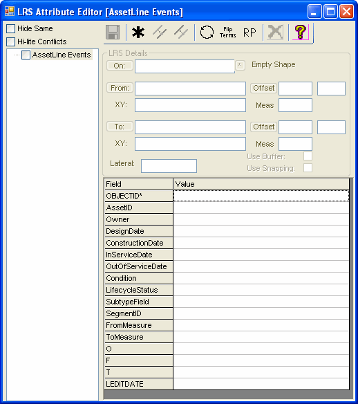
LRS Attribute Editor More...
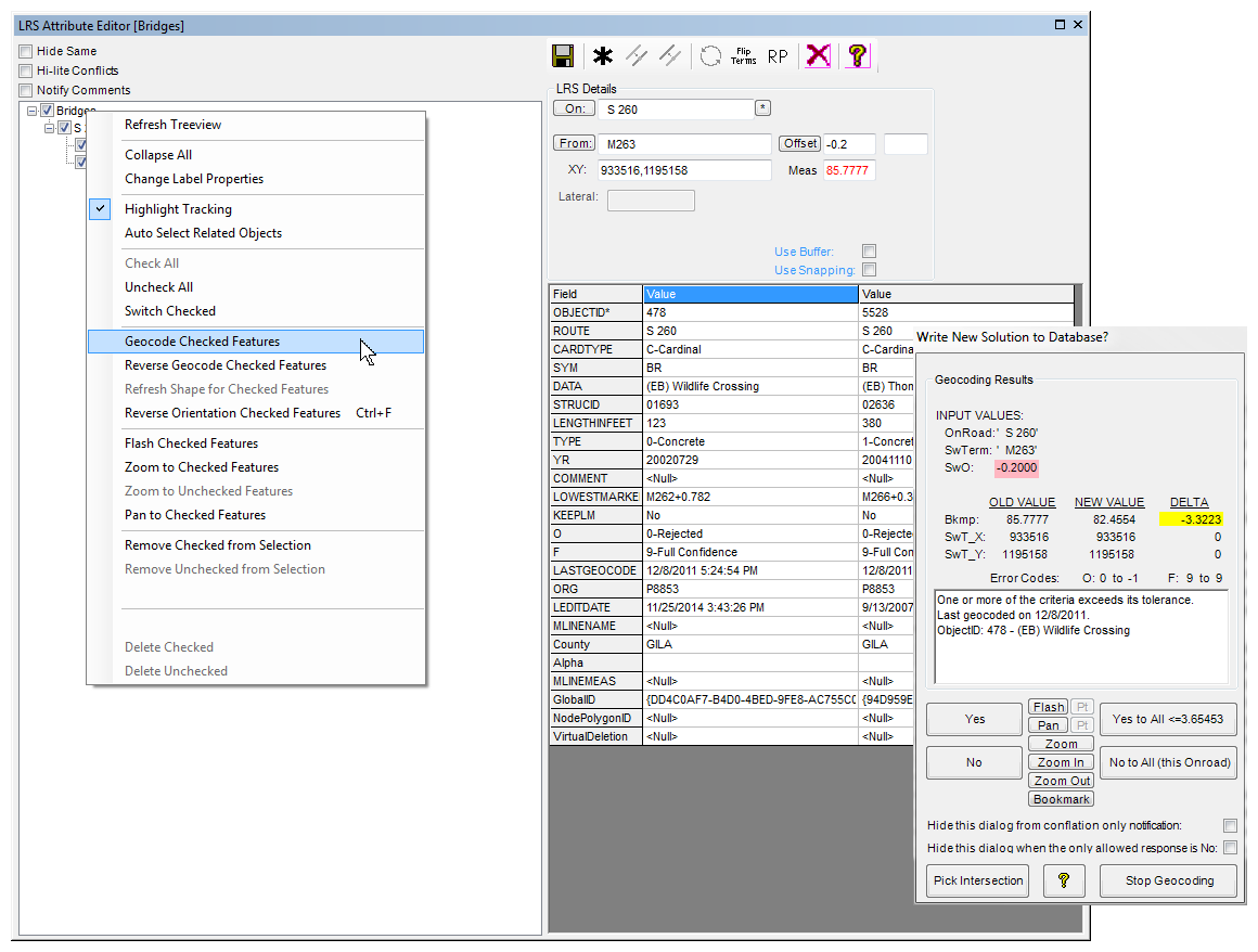
Geocoder/Conflator More...
Reverse Geocoder More...
Refresh LRS Shape More...
Measure Display More...
Overlap EvaluatorMore...
Multiples Generator More...
Calculate Referent Offset Direction More...
Referent Reconciler More...
Copy Multiple Features More...
Dissolve LRS Events More...
... is the foundation of the Lite toolset. (There is still so much more efficiency functionality packed into this event editing interface that Esri Roads and Highways RCE users have no idea how easy life can be.) LRS Tools has made quite an impression on the development of RCE, but there are still many agile stories that were never implemented in RCE.
__________________________________
LRS Lite allows the technician full control of the way events are treated in the wake of an edit to a route or its measurement values. When an OnRoad/Referent pair (assigned to an event) appears to be unsupported by the current library -- LRS Lite will offer you the ability to quickly manually adjust the event -- OR offer the artificial intelligence of its Conflation functionality to attach the replacement OnRoad/Referent to the event.
If you appreciate the embedded auto-adjustments of R&H, try the Universal Geocoder in LRS Tools so that the technician can assume more control over event behaviors.
__________________________________
LRS Lite has the most extensive library of utilities for assigning description from position. We have always defined geocoding as resolving position from description, whereas reverse geocoding is resolving description from position.
Therefore, if you have a bulk of spatial data without description -- consider that LRS Tools (and Works Consulting) is your best available resource for assigning OnRoad/Referent values (as well as LRS measures) to your shapes that need to behave like events.
__________________________________
... or even attach to the intersection library provided in the Roads & Highways ALRS (though you'll have to do with limited functionality compared to an LRS Tools library).
__________________________________
... even though events prefer to re-adjust and migrate as route measures are adjusted.
LRS Lite has specific capability to refresh event shapes when the user requires. LRS Lite is also smart enough to know when you expect the shape to adjust. Of course, test it out, and if you refresh a shape errantly -- you can always retreat by performing an "Undo" -- a feature that RCE does not support.
__________________________________
...on routes in plan view -- or even on routes in profile view (image generated with Curve and Grade toolset). The measure display button also provides for "part" notation on multi-part lines. The tools exemplifies the high qualities of the LRS Advanced Route Builder.
Clear the map view of all graphic notations with the General toolset's Delete Graphics button (or use Esri's 2-step process).
__________________________________
Some datasets are designed to represent a complete coverage of inventory -- without any overlap - temporal or otherwise. Use this ArcMap desktop tool to quickly check your events/features when they are expected to be non-overlapping. (In overlapping datasets, use a selected set or definition query to limit events that are not supposed to overlap.)
__________________________________
Understand your options when you employ multiple OnRoad name options per single centerline edge -- some non-GIS systems cannot make adequate associations between the same location with different OnRoad names.
The Generate Multiples tool creates an index of alternative naming conventions that can be used by 3rd-party and non-GIS systems.
__________________________________
Endow your non-zero-offset events with directional attributes like N, S, E, and W -- or NE, SW, NW, and SE. If you are trying to express your event data in descriptive form -- pluses and minuses just do not cut it. However, if you are trying to augment R&H event data -- you will have to upgrade the Intersection Table feature class to advanced LRS Tools functionality -- or simply use LRS Tools alongside R&H.
__________________________________
... with the Referent Reconciler. Check your enterprise events against a different library to determine the amount of conflation that will be necessary. Use the results to make assignments so OnRoads and Referents can be mass conflated in accordance with matching patterns. A must if you have large amounts of enterprise events/features that need to adapt to a new naming scheme. Also valuable for matching events from outside agencies to merge into your Roads and Highways nomenclatures.
__________________________________
... to enable the creation of new data in patterns. Many transportation inventory items are repetitive (i.e. a taper right-turn lane is followed by a full right-turn lane - even though their lengths are often different). The Copy Multiple Features functionality in the LRS Attribute Editor provides for quick replication of same inventory in a different place with different spatial extents. Allows you to generate new features extremely quickly.
__________________________________
... while maintaining discrete referent information. Often contiguous LRS events become more fragmented than they need to be. Route A between referent B and referent C has the same attributes as between referent C and referent D. Therefore, you may want to dissolve (bulk merge) the events so that the two events become represented fully as referent B to referent D.
The Dissolve LRS Events function works inside of LRS Attribute Editor as the "Merge" function on 2 or more records. The tool works on bulk quantities of events to process large datasets into smaller bulks of records.
__________________________________
If you participate in the roadway centerline specialty, this combination of Data Reviewer, Workflow Manager, and Task Assistant Manager offers the linear referencing practitioner the most useful set of centerline quality control enhancements in our industry.
Many agencies that maintain street centerlines have carried forth a legacy from their Emergency 911 (E-911) dispatch system. The conventional street centerline schema -- with left and right, from and to address ranges -- has fit the function of dispatch software.
__________________________________
The LRS Data Reviewer workflow is focused on building legitimate routes using arc naming provided by the data owner. However, perfect E911 centerlines have an additional set of rules to guide you when a linear referencing system becomes an objective.
__________________________________
... LRS Data Reviewer incorporates some of the fundamental checks of the Esri Data Reviewer - but dwells on an area of quality control that hasn't received much focus in the industry. Our tasks quickly build routes and identify areas of bifurcation. On the first run, most E911 compliant centerlines are loaded with bifurcations -- unless your organization is already LRS-endowed (you know what we mean).
__________________________________
A bifurcation is any location where more than two arcs of the same name touch each other. Bifurcations are identified in a very speedy manner by special tools in LRS Data Reviewer.
__________________________________
The LRS Data Reviewer doesn't care that your data has bifurcations -- because the process knows how to eliminate any and all bifurcations. Of course, we'd rather see everybody adopt "best", if not good, LRS centerline construction and attribution techniques. But in case you don't care, other users of your data can still move forward with high-quality LRS potential.
__________________________________
The LRS Data Reviewer typically can be processed in one to 4 hours time. Immediately following process completion, a layer package is issued to the data owner with specific locations and issues flagged. A workable route system is also generated so that LRS can be used without requiring the data owner to respond to flagged issues.
__________________________________
EditTracker is an transaction logger for ArcGIS that brings the edit history of a record to the immediate forefront knowledge of the user
Activities
Apply EditTracker to a feature class Video...
Tools/Buttons/MenuChoices
Add EditTracker Comment More...
Apply/Remove EditTracker More...
Create EditTracker Table More...
EditTracker History (ArcMap) More...
EditTracker History (HTML) More...
EditTracker History Column Filter More...
EditTracker History Time Filter More...
Flag Rows as Deleted More...
EditTracker Analyzer More...
Identify Classes Implementing EditTracker More...
You can be particular about which feature classes and tables to track. Objects in geodatabases (personal, file, and enterprise) are all supported. (Shapefiles once were supported – but we're moving on).
The dependency can be applied (or re-activated) in ArcCatalog, Catalog (in ArcMap), or using a geoprocessing tool (in workflows and models).
__________________________________
... although we've already considered your most obvious requirements. ET tables are automatically generated if the EditTracker is applied for the first time from Catalog (in ArcMap).
__________________________________
... the extension - when applied to a feature class or table - will remain in force until an administrator removes the dependency.
The dependency can be removed in ArcCatalog, Catalog (in ArcMap), or using a geoprocessing tool (in a model or workflow). Removing the dependency does not delete or destroy your EditTracker history -- it simply returns the object class to an untracked non-dependent state. (Remember to remove the dependency before sharing your data with non-EditTracker users.)
__________________________________
... the change activity is recorded in the table. New records, updates, and deletes are all recorded. Reporting options are integrated with the LRS Attribute Editor - but are also available in core ArcMap. Cell-based edits allow much higher granularity of history than provided by core ArcGIS.
__________________________________
...to any record or to any field within a record that utilizes EditTracker for ArcGIS. With no limit to the amount of custom comments allowed and the ability to comment on specific fields within records EditTracker for ArcGIS gives the user the flexibility to quickly and easily ensure that the story of each decision made for each record can be told.
__________________________________
... to include the age of the record, and other conditions regarding each edit (including who did it and when it was done). This capability drills down to each record-field change in the entire history since EditTracker was applied.
__________________________________
... so that the detailed history of any attribute can be assessed in chronologic order. Note that this report is presented in ArcMap table viewer (as opposed to a browser window).
__________________________________
This is very useful for when a particular historical change doesn't make any sense whatsoever - it may help to understand everything that was edited 10 minutes before and after the particular change in question.
__________________________________
... so long as the relationship class is enforced between the two objects.
__________________________________
ET tables can be gleaned of excess bloat with selection queries followed by deletes - if desired. If you use LRS Editor or/and do a lot of geocoding - ask about our special models that cure the bloat.
__________________________________
Deploy to all GIS staff. Create feedback threads (ToDo lists). Access Google StreetView or Bing Bird'sEye. Use the PanTracker to review your viewing.
Tools/Buttons
Copy Map XY to Clipboard Help
Delete Graphics Help
Google Spot
Open Bing Map Help
Open Google Map Help
Pan Tracker Help
Post Issue to Web Help
Set Selectable Layers to Active Layers Help
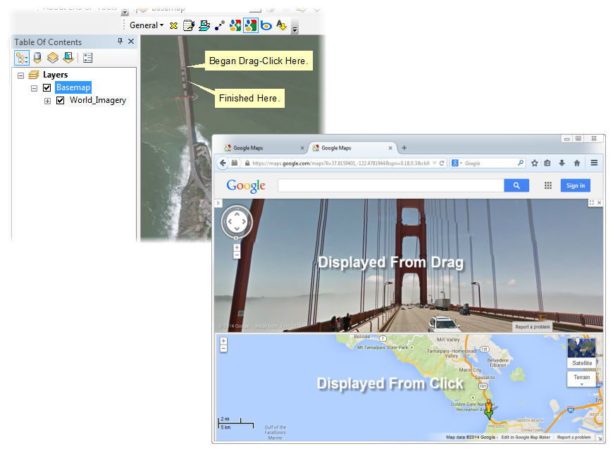
Use the Open Google Map tool and a single click to bring up that clicked location in maps.google.com. Use a click and a drag with the same tool and you bring up a StreetView of the location. Use the Open Bing Map tool to do the same -- but the drag will show perspective of the Birdseye View.
__________________________________
Happen to be browsing a classic Google Map and want to relate a visible feature to your ArcMap session? Right-click on the Google map view and select the "What's Here?" menu option. Notice that the longitude/latitude appears in the search bar. Select and copy to your clipboard. Then go to ArcMap and press the Google Spot button. Watch the ArcMap view center on the same spot that was identified in Google.
__________________________________
Sometimes it seems you've lost your place and are not sure what you've reviewed? Use the PanTracker to keep track of what you've viewed, the scale you viewed at, and the amount of time you spent on each frame.
Managers can implement the PanTracker to improve quality assurance - knowing if certain areas of review were skipped or inadequately scanned.
__________________________________
... with the Post Issue to Web widget. A reviewer who notices an issue with their (or somebody else's) GIS data can quickly post a "To-Do" issue to the data owner. Multiple agencies collaborating for the regional benefit need not correct each other's data redundantly. This work order ticketing system is backed by a web listing at www.itwillwork.com.
__________________________________
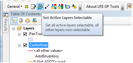
... when they took away some of our coolest ArcView 3.x tools? Long before Esri gave us 'Make This the Only Selectable Layer', we built the 'Set Selectable Layers to Active Layers' button. We still like our tool. We understand you do to - and we appreciate you.
__________________________________
... as often you'll be testing a world file or stretching some raster data with some geo-referencing tasks.
__________________________________
You can use the Delete Graphics button to remove extraneous text and graphics. Remember when Esri's tools used to delete features with graphics? We built this tool way back then. Since then, Esri has fixed their tool - but ours gives you results with 1 click, while ESRI makes you use 2 steps to clear graphics.
__________________________________
Do you need centerline attributes for roadway curvature or gradient? Sounds like you are in the roadway safety business - or you supply Highway Performance Monitoring System (HPMS) data to be consumed by your state or federal roadway agency? Scroll down to see the myriad of benefits provided through Curve and Grade Tools for ArcGIS.
Our preferred option is to process your GPS/centerline data (i.e. software as a service) and deliver the results with our toolset licensed for view-only mode. We have additional options to calculate and correct and consolidate your own wedges - or let our trained staff provide the corrections as a service.
Since roadway curvature and gradient are relatively stable over time, the data we provide as a service will last a lifetime. If you realign or flatten a roadway - send us a COGO or GPS trace and your data library can be updated.
As your LRS measures change from project-to-project, let LrsTools for ArcGIS reconcile your LRS attributes for compliance with temporal updates and a robust annual HPMS submittal.
Outputs
Gradients as Events in Plan video...
Gradients in Profile video coming...
Curves as Pies in Plan video coming...
Cleaning Curve Wedges video... silver...
Curves in Profile video coming...
Tools/Buttons
Compile Horizontal Curves More...
Construct Horizontal Curves More...
Construct Gradient Profile More...
Construct User Curve More...
Grade Rosette More...
Process Profile More...
Profile Gridlines More...
Switch Views
Geoprocessing Tools
Insert Vertices
Interpolate/Extrapolate Z-coordinates
... into wedges that represent radii of partial circles. Spiral curves are detectable, especially when working from coordinate geometry (COGO) vectors. If your GPS vehicle driver wavers, you will see those inconsistencies -- but the toolbox will also allow you to easily adjust for them.
__________________________________
... in a plan view, mileposts are shown along with curvature "wedges" that show the relative degree of curvature. Curvature is indirectly related to the length (i.e. radius) of each semi-circular wedge.
Wedges are typically not shown for Class A curves.
__________________________________
...that each individual wedge can be painted with a color depicting the curvature class. Every vertex offers a new wedge. Sometimes neighboring wedges straddle the fence between adjacent curvature classes (see the blue interspersed with green southeast of MP158 label).
Wedges are typically not shown for Class A curves.
__________________________________
... as fragmented data points create anomalies and bloat your table sizes. Use the 'Construct User Curve' tool and dialog interface to pick 3 points on the centerline and thereby override the multitude of vertices that create the anomalies. If you prefer your own "manufactured" wedge -- click on the Apply button to replace the GPS data with your own smoother wedge.
__________________________________
... when centerlines are acquired from GPS traces that flatten or sharpen when vehicle steering was not smooth during collection. Curve and Grade Tools allows raw data to be easily adjusted to remove anomalies and consolidate the data wedges into larger overall wedges of a far fewer number.
__________________________________
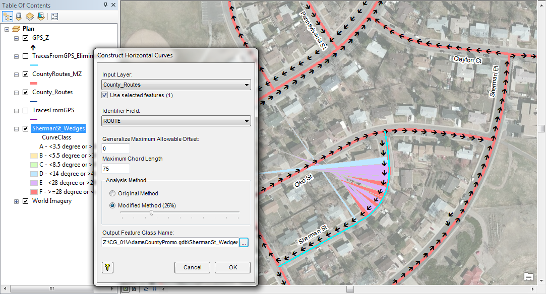
... and cover any renegade wedges by allowing the larger neighborhood to reign influence on them. The interface is shown in the slide above.
__________________________________
... and watch your ArcMap table of contents fill with a new data frame for every route that you choose to process.
__________________________________
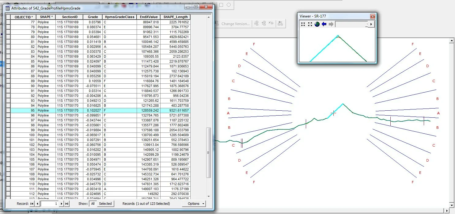
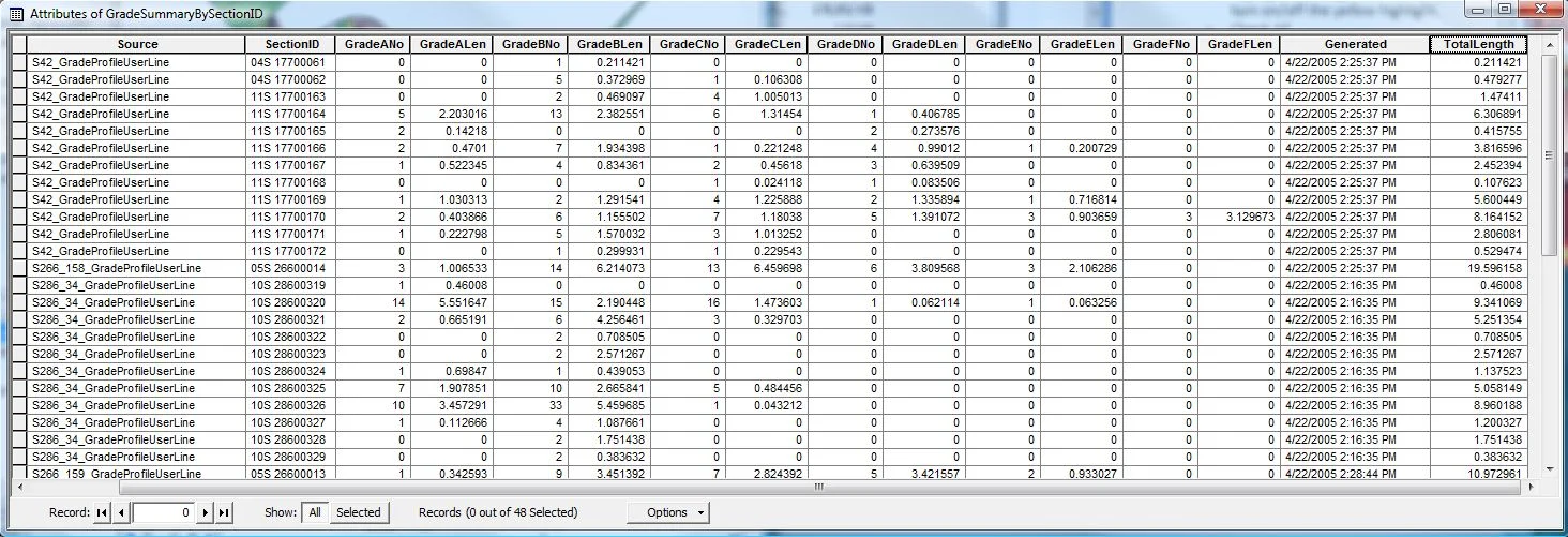
The image shows a customized ArcMap profile view with elevation (Y-axis) plotted against measured distance (X-axis). Specific accommodations are made for 3-D traveled length (when Z-coordinates are available) versus 2-D stationing length.
__________________________________
Attributes are calculated to each change-point of gradient classification. Route measures are compiled using the same linear referencing system (LRS) measures as your native centerline network. Associations can be made by selecting table rows to highlight profile segments. The "grade rosette" scales to accurately depict the range of HPMS-sanctione classes A through F.
__________________________________
... so that results can be directly useful to your existing workflows. With the 2010+ HPMS model, it makes sense to summarize curvature separate from gradient to minimize the overall number of records uploaded to HPMS. Whatever your need, the output can be published in multiple forms most suitable to your business requirements.
__________________________________
Generate centerlines from GPS traces using Centerline Sketch. Extend spatial joins with Spatial Select and Assign. Name centerlines with Street Name Builder. Give centerlines efficient address ranges with Assign LRS Address Ranges. Get stacked labels with One to Many Labeler.
Make BuiltFrom Table More...
Make Centerline Sketch More...
Make Centerline Table More...
One to Many Labeller More...
Point and Align More...
Point and Reach More...
Select Nearest and Assign More...
Spatial Select and Assign More...
Road Address Range Editor More...
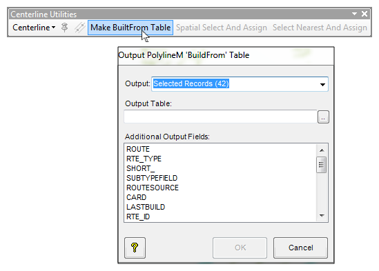
Use the Make BuiltFrom Table tool to generate a list of routes with their current octants of the zero-measure relative to the high-measure end. This has proven particularly useful in conversion projects from coverage data models — and in preparing agencies for efficient multi-name route building.
* * * * * * * * * * * * * * * * *
... and agencies that had dual GPS traces had no tools for averaging them to create an average trace – and use it as a centerline. Today, Esri provides the Cartography toolset that offers several options for centerline construction from multiple near-parallel lines. We've been using our own methods since ArcView 3.x and we continue to support them here.
* * * * * * * * * * * * * * * * *
... with the Make Centerlines Table you can establish a table of street names and Allen has to tell us the other reasons why this tool exists.
* * * * * * * * * * * * * * * * *
This functionality appears as an alternative labeling technique in feature layers that have relationship classes that assign multiple attributes to the same feature. This labeling method works very well for arcs that are related to (perhaps) many street names stored in a related table. It also works very well with traffic count locations that have many different historical traffic count results.
* * * * * * * * * * * * * * * * *
.. which extends the functionality of the Create Features core to quickly generate demarcation points that have a 'Reach' attribute which indicates the radius of influence around a demark. This tool supplies the point features used by the Insert Vertices geoprocessing tool in the Unification business process.
* * * * * * * * * * * * * * * * *
... which extends the functionality of the Create Features core to quickly generate points that have specific attributes that indicate the extent of desired colinear congruity between two arcs/routes from different sources. This tool supplies the point features used by the Retrace Partial Polylines geoprocessing tool that makes the routes have the same shape between pairs of points.
* * * * * * * * * * * * * * * * *
... a special application which allows for the population of results between features within a buffer distance without being forced to generate new output. Great for working with and improving enterprise master data.
... a special application of Esri's select by location functionality that allows for population of results without being forced to generate new output. It covers all of the spatial selection options of Esri's Select by Location... functionality. Great for working with and improving enterprise master data.
* * * * * * * * * * * * * * * * *
... with functionality provided by the Road Address Range Event Editor. Cut your E-911 polyline development cost by 80% or more – especially if your jurisdiction uses variable address blocks and skips large areas of the addressable range.
* * * * * * * * * * * * * * * * *
... or one arc can have any number of names. This is important for route aliasing without the hassle of duplicating shapes. We have customized forms for the input and assignment of road names according to specific field nomenclatures as well as assembled nomenclatures.
* * * * * * * * * * * * * * * * *
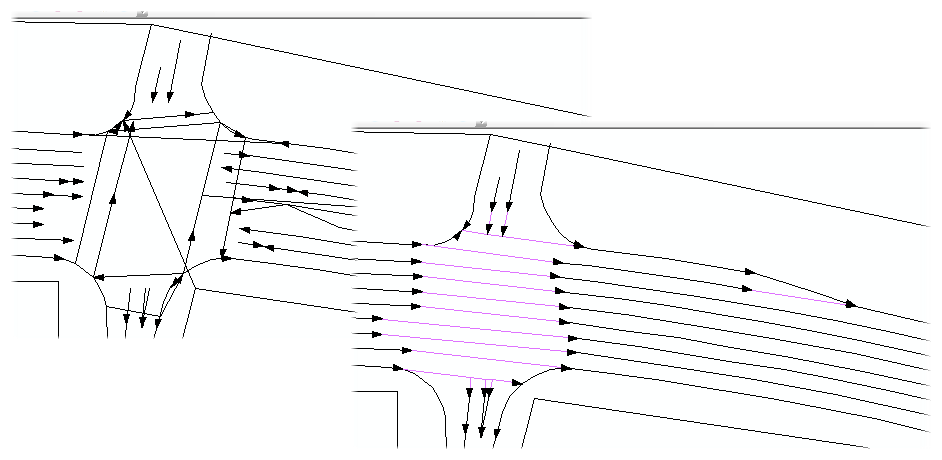
Exploit the value already invested in your CAD drawings or InRoads files by extracting the lines that represent roadway edges, lane striping, and other boundaries. Automatically generate linearly-referenced polygons (yes, LRS polygons) to make your R&H supported events that correlate with R&H intersection libraries as they become enterprise-available events. A must for efficient highway construction plan extractions.
Tools
Construct Long Polygons From Lines Demo Help
Display Cross Section Information Help
Display Cross Section Information by Measure Help
Populate Polygon Z-values with Width Help
...which could be a CAD design, LiDAR vectors, or even manually digitized vectors from a reliable raster source.
__________________________________
Some CAD files use short segments between stationing. Line-based Inventory provides algorithms for assembling lines in 'proximal contiguity'. This includes spanning lane lines across intersections as virtual lines - for the sake of defining a lane that relinquishes its boundary for a little bit of length while cross traffic encroaches the inventory.
__________________________________
The lines themselves get attributed for their color, continuity, and real vs. virtual. Each side of a line then gets attributed for whether it is the shoulder, earth, sidewalk, curb, lane (by number), inside shoulder, or median. Areas to the right of the cardinal centerline are '+'. Those in the opposite direction of travel are '-'. Area assignments are attached to points when there are a large number of lines (in an urban design). Rural areas typically require less attribution time because lines don't change attributes as often. The user can therefore attribute each side of long lines for overall speed performance.
__________________________________
Works Consulting has introduced the concept of the LRS polygon, which is a typically a polygon with its longer axis parallel to the centerline of the right-of-way. Also called long polygons, they are automatically generated from attributed lines by closing the short end(s) and then assigning a functional attribute from the areal definition point (typical for shorter urban lines) or the delineation fields (on each side of longer rural lines).
Long polygons are LRS-enabled as each vertex is reverse-geocoded to populate the measure projected from/to the LRS datum (i.e the LRS measure). The Z-placeholder on each vertex stores the width of the polygon across the long axis to the other side. These are very smart polygons. These concepts for smart inventory are available only through LrsTools.
__________________________________
Since these polygons are typically oriented to the LRS centerline datum, they have already been endowed with measures at each vertice. The minimum and maximum value for each individual polygon represent to linear extent. This translates into a linear event, whereby the minimum width, maximum width, and area (including average width) can be assimilated to each lane, shoulder, median, sidewalk, or roadside element. No more extracting these inventories from paper plans.
__________________________________
Transportation GIS technicians have typically resolved all inventories to line or point events referenced against the linear measuring system. With Line-based Inventory, every linear event has a supporting aerial representation shaped as a polygon - which can be overlain on aerial images to offer a better understanding of space. All events that arrive in the form of a construction project can be attributed together (with an open-to-traffic date on each element -- or a project number on each element that can be tied to an open-to-traffic date for the entire project) to give a sense of time. These space-time events can be appended to existing inventories to provide a truly temporal GIS experience.
__________________________________
Not only will your Roadway Reporter (or Highway Log) files be endowed with attributes conveying widths and quantities of shoulders, lanes, and channelization -- but the GIS environment provides the end-user with a very special couplet of tools that draws a cross section across either or both sides of any Line-Based Inventory roadway.
__________________________________
Are you a fan of Geoprocessing Tools? Within ModelBuilder or elsewhere in the ArcGIS workspace? Many of our landmark methods are available for integration into your workflows using our custom Python scripts and .Net geoprocessing tools.
LRS Utilities Toolset
Add Virtual Markers to LRS Tables More...
Assign Nearest More...
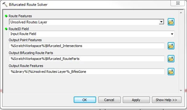
Bifurcated Route Solver More...
Calculate LRS Measure Fields More...
Calculate LRS Measure from XY Fields More...
Calculate Nearest Marker Field More...
Dissolve LRS Features More...
Flag Bifurcating Polyline Features More...
Four-table Route Builder More...
Make Finite LRS Events More...
Redact LRS Events More...
Redact Routes More...
ReOrient And Measure Routes More...
Select by LRS Reference More...
EditTracker Utilities Toolset
Apply EditTracker Extension More...
Enable or Disable EditTracker Extension More...
Remove EditTracker Extension More...
Geoprocessing Utilities Toolset
Factor Measures More...
Insert Vertices More...
Interpolate/Extrapolate Z-Coordinates More...
Retrace Partial Polylines More...
Line-Based Inventory Toolset
Add Features to Connect Proximal Features More...
Intersect Line-based Polygons w/ LRS Events More...
At-Large Tools
Make Line Events From Point Events More...
Break Range into Bins of Max Range Value More...
Export Table to Delimited File More...
Sample Panel - Stats by Vol Group More…
Increment/Decrement More…

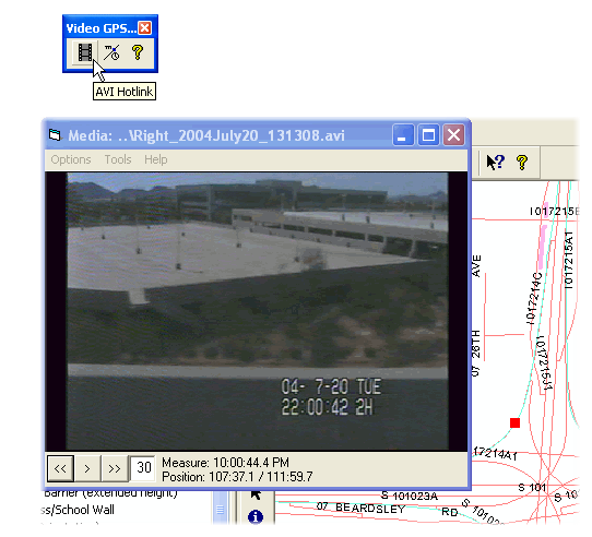
The GPS Tools for ArcGIS support the transformation of GPS data points into line traces in a significantly more effective manner than provided by the core Esri products. Also included in this tool set is the GPS AVI player which allows a video file to be sequenced against the GPS trace collected during the video capture.
Functionality
GPS Capture
AVI Hotlink
Display M as Time
ASCII File Convert
... so that you can deploy a video cam while also collecting GPS – and deploy a low-cost videolog solution for collecting inventory. The hotlink button allows you to click any point on the generated polyline and access the precise video location.
~ ~ ~ ~ ~ ~ ~ ~ ~ ~ ~ ~ ~ ~ ~ ~ ~
... is a standalone Windows application for collecting GPS. We utilize it to assign position to our photolog applications that have been built for clients – as well as have been used by our own personnel for data collection projects performed for clients.
~ ~ ~ ~ ~ ~ ~ ~ ~ ~ ~ ~ ~ ~ ~ ~ ~
... does a specialized import of longitude, latitude, altitude, and time details from a GPS file. It turns it into a polyline ZM feature class.
~ ~ ~ ~ ~ ~ ~ ~ ~ ~ ~ ~ ~ ~ ~ ~ ~
... retrieves the measure from a PolylineM shape at the user-clicked point and displays it in a time-of-day format.
~ ~ ~ ~ ~ ~ ~ ~ ~ ~ ~ ~ ~ ~ ~ ~ ~